
Editors note: This is the first in a series of posts by the Civil War Preservation Trust on all of the wonderful educational resources they have to offer. Enjoy!
————————————————————————————————————————————————
As senior manager of education programs at The Civil War Preservation Trust (CWPT) I am extremely pleased to work with Teaching the Civil War with Technology and grateful for the wonderful platform Dr. Beeghley offers with this blog. Today I am excited to discuss the latest offering on our website; a new animated map depicting the Battle of Franklin, Tennessee.
Just to tell you a little bit about us, CWPT is America’s largest non-profit organization (501-C3) devoted to the preservation of our nation’s endangered Civil War battlefields. CWPT is also committed to providing educational programs and resources to inform the public of the war’s history and the fundamental conflicts that sparked it.
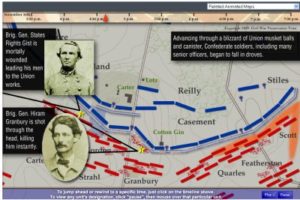
The animated maps are one of the feature educational offering of CWPT. The Franklin animated map, launched this week, is a part of a series of animated maps including: the Battle of Fredericksburg, Saving Bentonville, the First Day at Chancellorsville, the Battle of Chantilly, and the Battle of Cedar Creek. Through these animated maps the battles of the Civil War come to life.
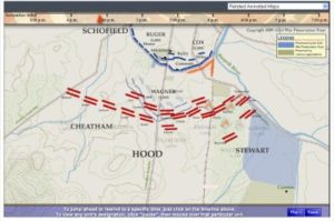
Over the past year CWPT has worked on these maps, gradually developing a template for the “animated map.” Taking the traditional static battle map, we have compressed the battle into a short/bite-size presentation, inserted a historical narrative, and set the once still armies into animated action. The outcome is a user friendly, high-speed learning experience for students of all ages.
In my opinion one of the greatest parts of the animated map is that it is not a static map sitting on a self or table by itself. The animated map is surrounded by information and resources. It is a full narration of the battle from beginning to end. The animated map provides the user with context for the battle, opening with an introduction which explains where and when the battle took place, who was involved, why the battle happened at that time and in that location.
During the battle troops can be seen moving in and around the battle, those that are not involved in the major action at a certain moment can still be seen. The user can also see the roads, topography of the land, rivers, and railroads. Historians have provided a narrative of the battle. As the battle progresses the narration follows along providing the user with information that could not be discussed on a static map. Following the battle there is discussion about what effects the battle had on the soldiers and community. The preservation efforts or lack there of are also discussed.
Another great feature of the animated map is the use of primary sources; newspaper articles, pictures, illustrations, and letters appear thought-out the animated map presentation. This provides the user with a visual context for the time and landscape in which the battle was fought. It also exposes the younger audience to the use and variety of primary sources.
As someone who began to learn about the Civil War fairly recently I really appreciate the animated map approach to military history. I never understood how a static battle map was useful, these always seemed to make me more confused. I needed to see the movement; I needed to know where the armies were coming from, and where they were going.
The animated map is useful at so many levels of Civil War scholarship. We are very fortunate to have the technology to do this and the ability to provide it free to all who want to learn about the war.
I hope to post again soon, Nicole Osier.
education@civilwar.org


Steve Stanley does a simply wonderful job with those maps. This past summer while in Gettysburg on one of my trips, I watched Steve work on an animated map. Amazed me. And the finished work is stunning and an astonishing educational tool.
J.D.